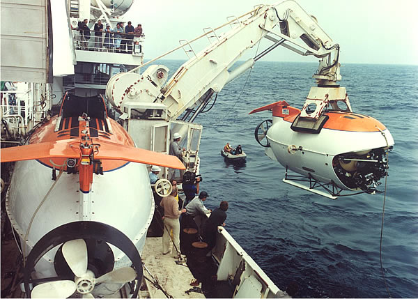
 The most valuable scientific equipment includes the two manned submersibles (GOA) Mir-1 and Mir-2, developed by the Institute and built in Finland, with a working depth of up to 6000 m, as well as a ship system for raising and lowering them. These are the best-in-class devices in the world. Together with the RV Akademik Mstislav Keldysh, GOA Mir make up a unique instrumental complex.
For 30 years of its existence, with the help of the Mir GOA, a colossal amount of scientific research, archaeological work, video filming of underwater objects in the World Ocean has been carried out, as well as tasks of national importance have been solved on the sunken nuclear submarines Komsomolets and Kursk, unique research has been carried out on Lake Baikal.
The Institute has also created and operates unique instrumental systems for ocean research:
- shipboard instrumentation systems that allow measuring and analyzing the chemical composition and physical characteristics of the atmosphere and the near-surface part of the ocean's water column, as well as its turbidity and composition of surface pollution;
- geophysical towed and onboard complexes (Sound, Hydra, Mesoscan, Microsound, ChirpSonar, AP-5, Sparker, etc.), allowing for panoramic sonar mapping of the bottom relief, searching for underwater objects, seismic profiling of sedimentary strata, as well as measurements of the geomagnetic field;
- deep-water buoy stations, allowing to measure hydrophysical, geochemical and acoustic parameters of water, as well as to investigate sedimentation processes (sedimentation traps "SL-6") at maximum depths in the ocean;
- bottom instrumental systems (stations), which allow registering magnetic, seismic and acoustic signals, noise and microseisms, as well as numerically assessing material flows and geochemical processes occurring at the water-bottom boundary;
- underwater robotic platforms "GNOM", allowing visual inspection of underwater natural and man-made objects, targeted sampling and measurements;
- a computing multicore complex based on the CRAY CX1 platform and an information storage system including a distributed disk configuration;
- autonomous sounding systems of the Aqualog series, designed to obtain continuous series of measurements of vertical profiles of hydrophysical parameters of the water column at an anchored station;
- ultraviolet fluorescent lidars of the UVL series of our own design for high-resolution mapping of the fields of concentration of chlorophyll, dissolved organic matter and mineral suspension in the ocean;
- a deep-water towed complex - an unmanned underwater vehicle (UUV) "Videomodul", intended for visual observation and route mapping of the bottom micro-relief and populations of bottom fauna at maximum depths in the ocean