


S.K. Klimenko and A.Yu. Ivanov, employees of the Laboratory of Ocean Optics of the Institute of Oceanology of the Russian Academy of Sciences, analyzed the available data of Earth remote sensing (ERS) from space, which showed the fuel oil pollution of the Kerch Strait and the waters of the Black Sea pre-strait, which occurred as a result of the sinking of the tankers Volgoneft-212 and Volgoneft-239 on December 15, 2024.
During the observation period from 15.12.2024 to 26.08.2025, using exclusively radar data from the European Sentinel-1A and Sentinel-1C satellites, as well as a number of satellites that provided images within the framework of the International Charter on Space and Major Disasters (Home | International Charter: Space and Major Disasters), more than 50 radar images (RLI) were analyzed, based on which an integrated map of pollution caused by fuel oil spills was compiled using a GIS approach. Thanks to it, it is possible to assess the scale of the spread of fuel oil films and its aggregates on the sea surface - from sunken tankers to Cape Maly Utrish, in the Kerch Strait and along the southern coast of Crimea up to the city of Sevastopol. The conclusions in article have not been confirmed, and since April 2025 there has been a continuation of the occurrence in the area of the accident, as well as secondary contamination in the form of orthogonal creep strips near the coastal zone of Bugay Spit and the coastline of Anapa.
The analysis of remote sensing data and the final integrated map allowed us to: 1) fairly accurately establish the position of the sunken parts of the tankers on the seabed immediately after the disaster, 2) show that the tanker oil product was massively distributed under the influence of wind and drift currents over significant distances from the spill site (up to 60–90 km), and in almost all directions from the sources, 3) estimate the areas of maximum spills (~85–100 km2) and their total area (267 km2 in 2024 and 340 km2 in 2025), 4) estimate the total area of pollution spread in the Kerch Strait and the pre-strait area of the Black Sea (about 2270 km2), 5) identify the periods of the most intense spills (December-January, May-August 2025), etc.
The results show significant pollution of the strait and the Kerch Strait fore-strait due to the tanker accident. A significant amount of fuel oil remains in the sea, most of which has settled to the bottom or is still in the shallow banks near the Taman Peninsula, in the bottom sediments of the coastal zone of the Bugay Spit and the beaches of Anapa. Due to the summer heating of the water column and periodic storm impacts, fractions of heavy oil products rise and form films on the sea surface, which is confirmed by both radar data and sub-satellite observations (sea surface survey, underwater surveys, etc.) in the coastal zones of the region.
In addition to radar data, optical images available at the site of the tanker accident were used for observation, where the main ones were images from Sentinel-2 satellites. On them, starting from April 2025, under favorable hydrometeorological conditions, the color of the films is discernible, which indicates a leak of medium fractions of oil product (Fig. 1).
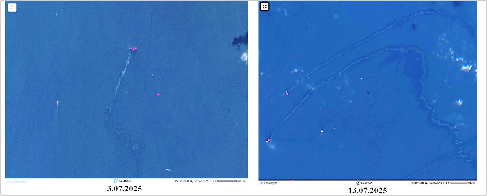
Fig. 1. Fragments of optical images from Sentinel-2 of the Kerch Strait, which show the color of the films.
The type of oil product that creates them can be characterized as transitional from heavy to medium
(the lilac dots show the sunken parts of tankers). © ESA
The formation of secondary pollution in the coastal zone of the Anapa agglomeration and the Bugay Spit was also observed in space images (Fig. 2). It was displayed as a series of slicks oriented orthogonally or parallel to the coast, which were observed on radar images on 17.05, 12.06, 10.07, 16.07, 18.07, 22.07, 24.07, 5.08 and 9.08.2025; their total area can reach 50 sq. km or more.
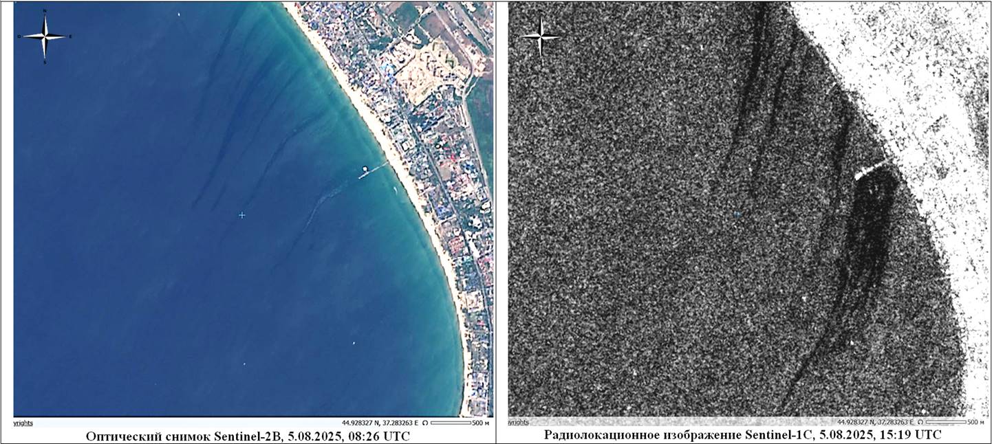
Fig. 2. Secondary film pollution of the coastal zone of Anapa
on quasi-synchronous images of the Sentinel-2 and Sentinel-1 satellites.
The color of the film on the optical image confirms the oil nature of the pollution.
Using remote sensing data, it was also established that the discharges from the sunken parts of the tankers have not yet been completely eliminated and the pollution of the waters of the north-eastern part of the Black Sea continues to this day (Fig. 3) and will probably continue to occur during the second half of 2025. Although positive trends in the restoration and natural development of benthic communities are observed, based on the above, we believe that at this stage it is not possible to make an objective final assessment of the environmental damage, especially in the context of ongoing pollution.
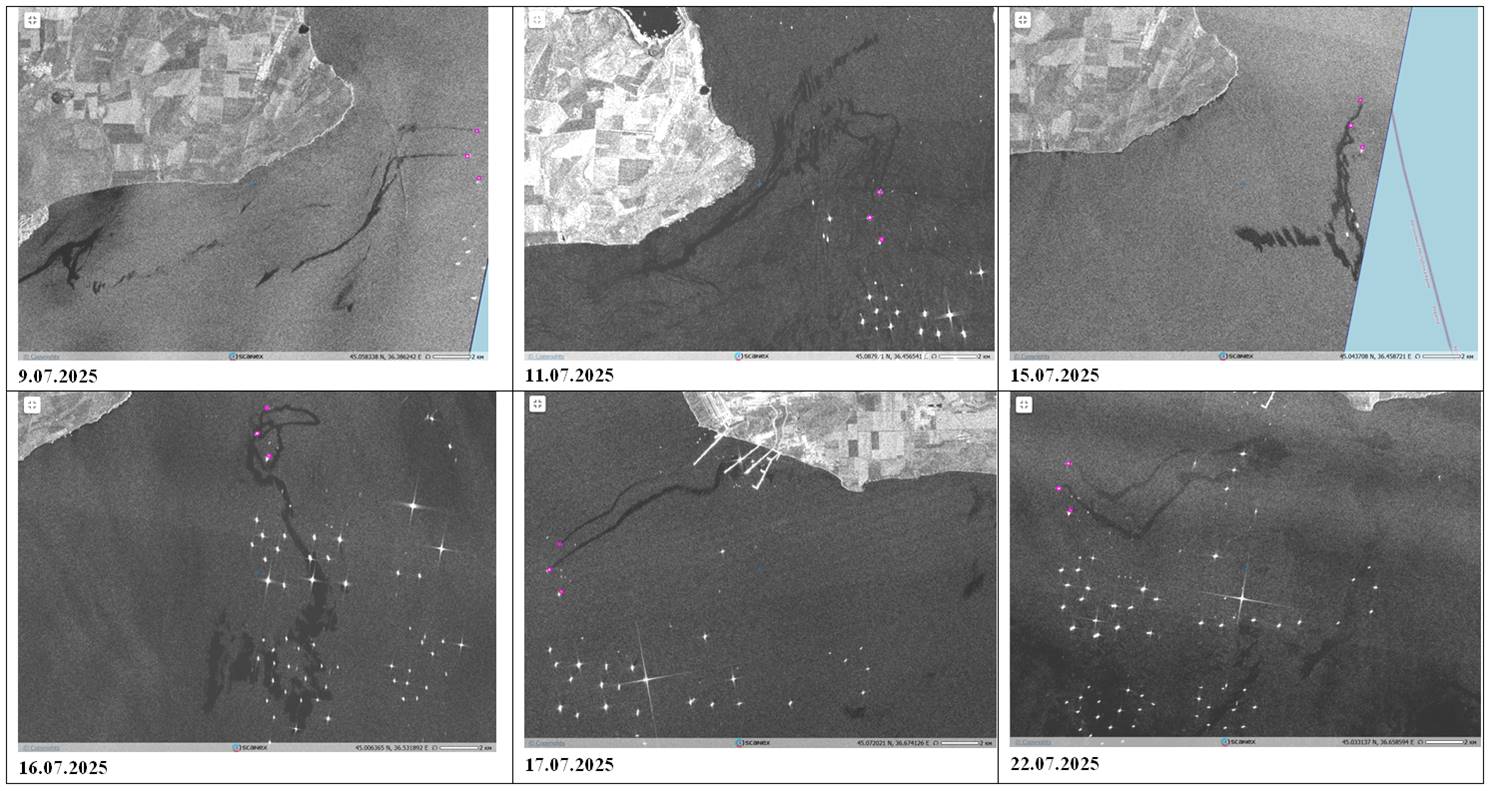
Fig. 3. A selection of the latest Sentinel-1 radar images, which clearly show extensive pollution of both
the waters of the Kerch Strait and the coastal zones of Taman and Crimea (the purple dots are the sunken parts
of the Volgoneft-212 and Volgoneft-239 tankers).
As a result, the remote sensing data allowed us to establish the sources and preliminary scale of pollution of the marine environment of the Kerch Strait and the pre-strait area with oil products, as well as to detect secondary pollution formed in the coastal zone of Anapa and the Bugay Spit. However, for the most reliable assessments and analysis of its consequences on the marine and coastal ecosystems, it is necessary to continue observations and apply complex methods, including the use of remote sensing data verified by expeditionary research with the collection and analysis of water samples and bottom sediments in the pollution zones.
